
Spillway and Embankment Condition Assessment - GPR and 3D Imaging
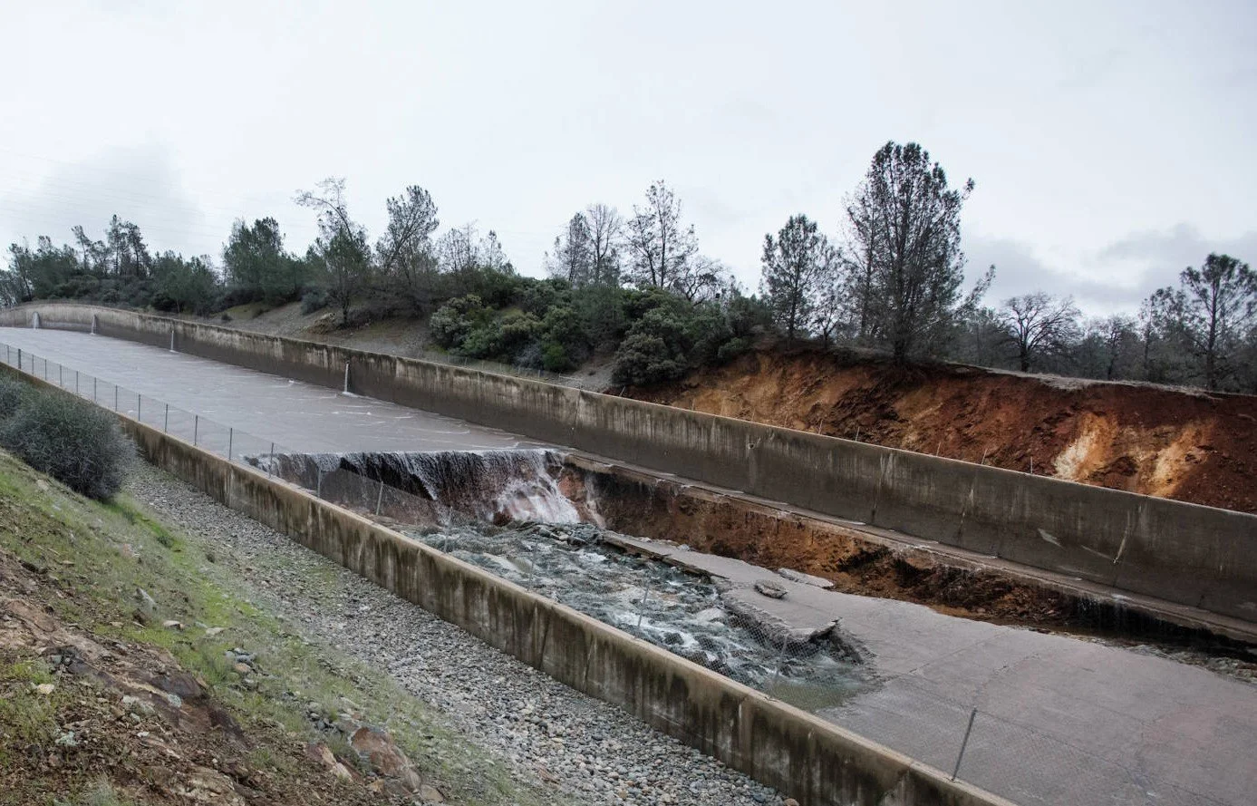
Concrete spillway showing catastrophic structural failure with collapsed panels, exposed soil and active water flowing through the breach.
Embankment dams and concrete spillways are critical flood control structures, designed to hold back enormous volumes of water and protect residential and commercial properties from catastrophic damage. When a major flood event occurs, the visible aftermath - waterlogged properties, surface erosion, structural damage above grade - is only part of the picture.
The greater risk is often what happens underground.
The Challenge: Hidden Hazards Beneath Flood-Affected Structures
Water is persistent. As floodwaters move through and around a structure, they carry soil with them - and that soil doesn't come back. Whether the process takes years or happens in a single event, the result is the same: compacted soil is washed out from behind and beneath concrete panels, leaving voids that are invisible to the naked eye.
A void beneath a flood control structure is not a minor defect. It is a structural hazard. A concrete embankment or spillway panel that appears intact on the surface may have lost the soil support required for it to perform as designed. Without that support, the structure cannot withstand the lateral force of water it was built to contain.
This type of risk falls into the category of unknown subsurface hazards — and it demands investigation following any significant flood event.
The Approach: GPR Condition Assessment
OmniVueNDT conducted a Ground Penetrating Radar (GPR) survey on a concrete embankment affected by a previous major flood event. GPR is a proven Non-Destructive Engineering (NDE) method well suited to this application — it is fast, non-invasive and capable of detecting subsurface anomalies across large areas in a single mobilization.
Survey data was collected with RTK correction, providing GPS-accurate coordinates tied directly to any detected anomalies. This allows findings to be mapped precisely and delivered in a format compatible with AutoCAD 2D/3D and other Autodesk platforms, giving engineers and project owners a clear, actionable record for remediation planning.
Results
The GPR survey confirmed that significant soil washout had occurred behind the concrete embankment panels as a direct result of the prior flood event. Affected areas were identified and mapped across the structure's surface.

Aerial view of a concrete embankment with GPR-detected void and washout zones marked by pink and red polygons at GRID010 and GRID011 locations, with a ground-level inset photo showing the affected area.
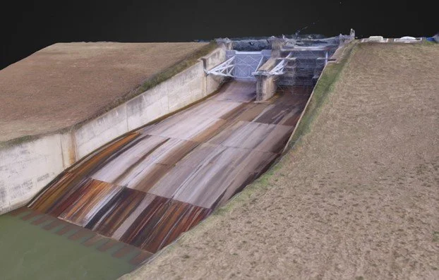
The collected radar data was then processed alongside a 3D structural model of the spillway, produced using LiDAR scanning to capture the full structure in detail.
3D LiDAR structural model of a concrete spillway showing the full length of the structure, surrounding embankment and gate mechanism.
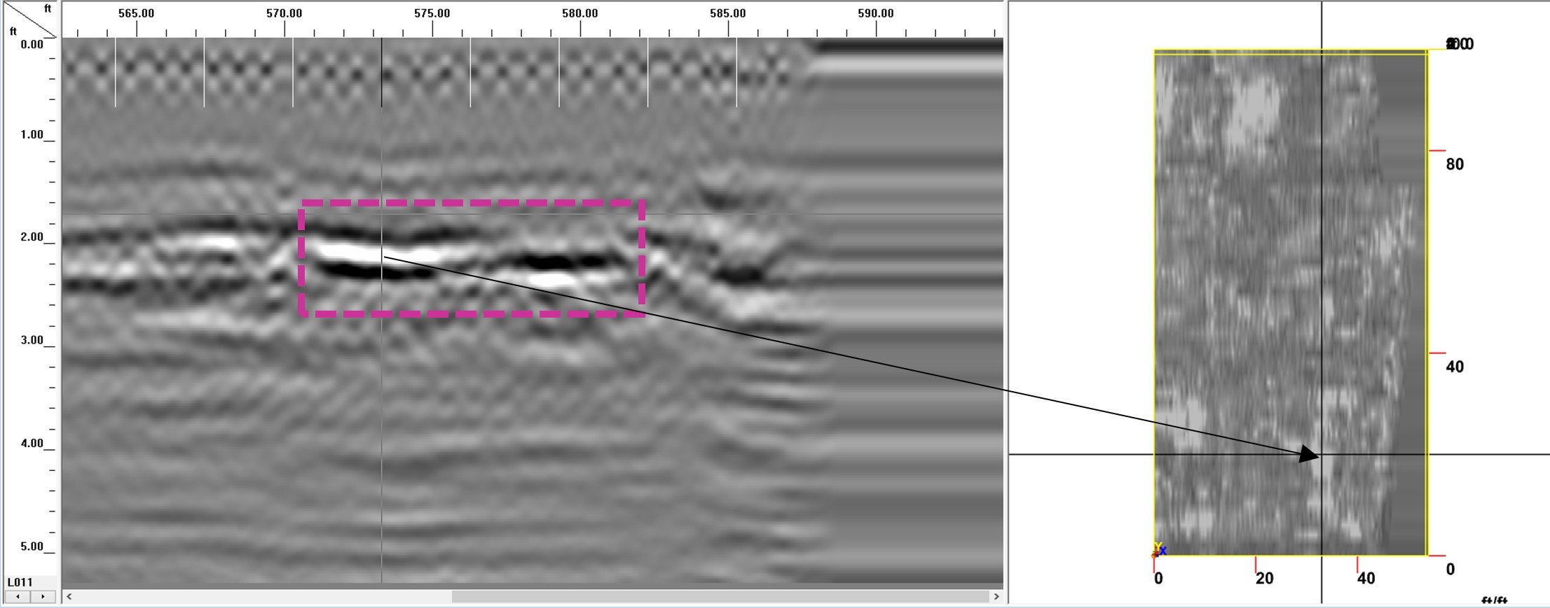
The GPR profile confirmed the presence of a subsurface anomaly at approximately 2–3 feet of depth, consistent with void or washout conditions beneath the concrete structure.
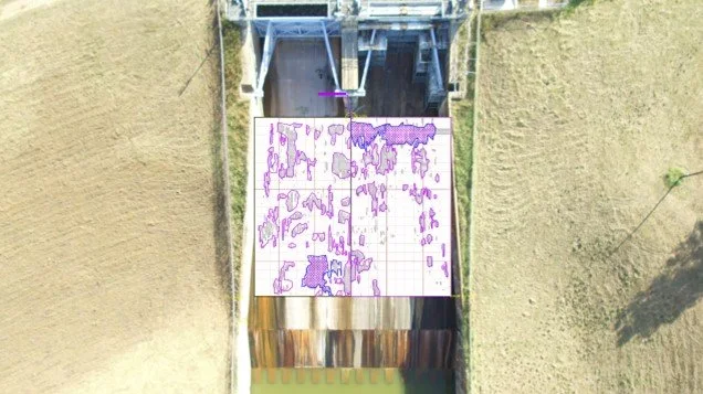
Top-down aerial view of a concrete spillway with GPR scan grid overlay, showing purple contour markings indicating the location and distribution of detected subsurface voids across the scanned surface.
The GPR data was overlaid onto the 3D LiDAR model of the spillway, combining subsurface findings with the full structural model to clearly indicate the location and extent of voids for engineering review and future remediation planning.
3D LiDAR structural model of a concrete spillway with GPR data overlaid, showing the full length of the structure, surrounding embankment and gate mechanism.
Flood-damaged structures require more than a visual inspection. The subsurface conditions that make a flood control structure unsafe are, by definition, out of sight. GPR-based condition assessments provide the data engineers need to verify structural integrity, prioritize remediation and deliver findings in a format ready for design and construction teams.
If your facility or infrastructure has been affected by flooding, contact OmniVueNDT to discuss a subsurface condition assessment.