
Subsurface Void Mapping & Condition Assessment with GPR
Non-destructive evaluation of subsurface conditions to identify voids, loss of support, and hidden anomalies prior to crane placement and heavy equipment operations
Subsurface Void Mapping Using Ground Penetrating Radar
Subsurface void mapping is a non-destructive assessment method used to evaluate hidden conditions beneath concrete slabs, industrial pads, and pavement systems. This type of investigation is commonly performed prior to crane placement or heavy machinery operations, particularly in industrial environments such as refineries, chemical plants, and infrastructure sites where ground instability presents elevated risk.
Rather than measuring only pavement layer thickness, this assessment focuses on identifying potential subsurface voids, washout conditions, loss of support, or anomalous zones that may compromise structural stability under load. Undetected voids beneath crane pads or lifting zones can increase the risk of settlement, structural failure, or unsafe lifting conditions.
To help reduce these risks, OmniVueNDT performs comprehensive subsurface condition assessments using mid-frequency Ground Penetrating Radar (GPR) systems designed to evaluate changes in material density and detect subsurface anomalies.
GPR-Based 3D Subsurface Void Mapping
Subsurface void mapping is conducted through a formal 3D GPR survey in which radar data is collected across the designated scan area using a consistent grid pattern. Typical scan line spacing ranges from 1 to 4 feet, depending on project requirements, surface conditions, and desired resolution.
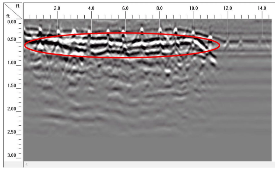
As radar data is collected, variations in reflected signals are analyzed to identify discontinuities, air gaps, washout zones, or changes in subsurface material properties. These reflections may indicate potential voids, subsurface anomalies, or areas of reduced support beneath the surface structure.
The collected data allows for visualization of subsurface conditions across the entire scan area, providing a clearer understanding of structural support conditions prior to loading or lifting operations.
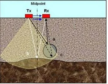
Ground Penetrating Radar wave propagation showing how radar signals detect subsurface layers and anomalies.
Data Processing and Interpretation
Following data collection, the GPR dataset is processed to support interpretation and visualization of subsurface conditions. This process may include:
Data interpolation and digital model creation
Identification of potential voids or anomalous zones
Export of numeric data in ASCII format for engineering review
Creation of digital contour maps illustrating subsurface condition variations
Field mark-out of areas where anomalies or loss-of-support conditions are detected
The objective of this process is to provide actionable insight into subsurface conditions without excavation or destructive testing.
These outputs provide project teams with actionable information to support planning and risk mitigation prior to equipment loading or lifting operations.

GPR cross-section analysis identifying subsurface anomalies and potential voids beneath industrial pavement.
Typical Applications
Subsurface void mapping and condition assessment is commonly used for:
Crane and heavy equipment placement planning
Industrial pad and foundation evaluation
Risk mitigation prior to lifting or hoisting operations
Assessment of potential washout or erosion beneath slabs
Investigation of suspected subsurface anomalies
Evaluation of load-bearing conditions before structural modifications
Important Considerations
Ground Penetrating Radar is a non-destructive, interpretive technology. Results may vary depending on material composition, moisture conditions, depth of investigation, and subsurface complexity. GPR-based void mapping does not replace geotechnical or structural engineering evaluation, and final decisions regarding crane placement, equipment loading, or structural capacity remain the responsibility of the project team.
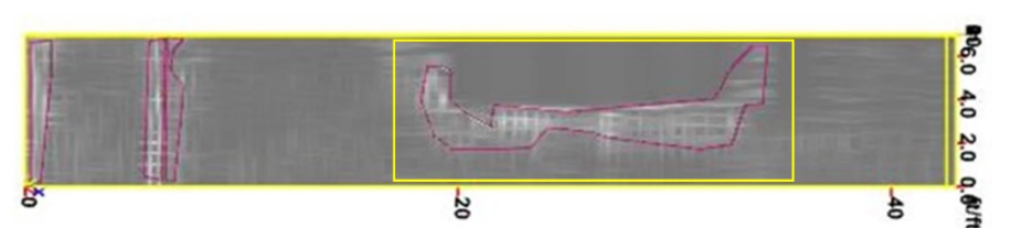
3D radar mapping showing subsurface void locations with equipment placement footprint overlay for safe work planning.
Planning Heavy Equipment or Crane Placement?
Subsurface void mapping and condition assessment provides critical insight into hidden conditions before high-load operations begin. Identifying voids and loss-of-support areas early helps reduce risk, improve safety, and support informed engineering decisions.